Environmental conditions that restrict the growth, distribution, or abundance of a population within an ecosystem.
Latitude
The distance north or south of the equator, influencing climate patterns such as temperature and insolation.
Precipitation
Any form of water (rain, snow, sleet, hail) that falls from the atmosphere to the Earth’s surface, affecting water availability in ecosystems.
Insolation
The amount of solar radiation received by a given area, influencing temperature and primary productivity.
🧠 Exam Tip: Link limiting factors to carrying capacity in longer responses, and latitude and insolation to biome distribution when possible.
📌 Weather and Climate
What is the difference between weather and climate?
Weather refers to the current state of the atmosphere at a specific time and place
Weather conditions can changerapidly (e.g. over just a few hours)
This includes short-term variations in:
Temperature
Humidity
Cloud cover
Precipitation
Wind speed
Air pressure
Other atmospheric conditions
Climate refers to the long-term average of weather conditions in a particular region or location
It describes the overall patterns, trends and variations in atmospheric factors (temperature, humidity etc.) over relatively long time periods
Climate is the average of these conditions over approximately 30 years or more
Climate is influenced by various factors such as solar radiation, atmospheric circulation patterns, ocean currents, land features and greenhouse gas concentrations
Climate provides a broader perspective on long-term atmospheric behaviour
Whereas, weather is more concerned with immediate atmospheric conditions and forecasts
Understanding the difference between climate and weather is crucial for:
Analysing long-term climate trends
Predicting short-term weather events
Assessing the impacts of climate change on weather patterns
📌 Biomes
What are biomes?
A biome is a group of similar ecosystems that have developed in similar climatic conditions
Biomes are large-scale ecological communities or ecosystem types
They are characterised by their dominant vegetation, climate and other abiotic factors
These factors shape their biotic communities
Biomes cover large geographic areas
Multiple ecosystems can be found within a single biome
Biomes can be categorised into groups including:
Freshwater biomes
Marine biomes
Forest biomes
Grassland biomes
Desert biomes
Tundra biomes
Each of these groups has characteristic abiotic limiting factors, productivity and biodiversity
These groups can be divided into further categories, for example:
Forest biomes are dominated by trees and can be further divided into:
Tropical rainforests
Temperateforests
Boreal forests
Grassland biomes are characterised by grasses and herbaceous plants and can be further divided into:
Savannas
Temperate grasslands
Desert biomes are characterised by low rainfall and are dominated by cacti and other drought-resistant plants—they can be further divided into:
Hot deserts
Cold deserts
Coastal deserts
Semi-arid deserts
Tundra biomes are found in high latitudes and are characterised by low temperatures and permafrost—they can be further divided:
Arctic tundra
Alpine tundra
Each biome has characteristic limiting factors that affect productivity and biodiversity
For example, in the desert biome, water is the limiting factor for plant growth, while in the tundra biome, low temperatures and permafrost limit plant growth
Forest Biomes
Characteristics
Tropical rainforest
Temperate forest
Boreal forest
Location
Low latitudesWithin Tropics: 23.5° north and south of equatorE.g. Amazon in South America, New Guinea, Southeast Asia, Zaire Basin
Between 40°–60° north and south of equatorE.g. Western Europe, northeast USA, Eastern Asia
Between 50°–60° north and south of equatorE.g. Canada, Russia, Scandinavia
Annual precipitation
Over 2000 mm
750–1500 mm (all year round)
300–900 mm (all year round)
Temperature range
26 to 28°C
Over 0° C in winter20 to 25°C in summer
-30°C in winterUp to 20°C in summer
Seasons
No seasons: hot and wet all year round
Four seasons of equal length
Two main seasons: winter and summer
Growing season
All year round
6–8 months
2–3 months
Soils
Relatively infertile due to leaching and rapid uptake of nutrients by plants
Relatively fertile and nutrient rich due to decomposition of organic matter over autumn and winter
Not very fertile: often acidic, with permafrostShallow soil with a thick litter layer due to slow decomposition
Biodiversity
Approx. 50% of world’s plant and animal species live within the rainforest biomeExample flora: mahogany, teak trees, lianas, orchidsExample fauna: Toucans, jaguars, frogs, snakes
Wide range of animals and plants with higher biodiversity than boreal forestsExample flora: deciduous trees e.g. beech, oak, birchExample fauna: deer, rabbits, squirrels, bears
Less biodiverse than temperate forestsExample flora: coniferous treesExample fauna: squirrels, bears, reindeer, wolves
Grassland Biomes
Characteristics
Savanna
Temperate grasslands
Location
5°–30° north and south of equatorNorth and south of tropical and monsoon forest biomesE.g. central Africa: Tanzania, Kenya
40°–60° north and south of equatorE.g.” veldts” of South Africa, “pampas” of Argentina, “steppes” of Russia, “plains” of USA
Annual precipitation
800–900 mm
250–750 mm
Temperature range
15–35°C
-40 to 40°C
Seasons
Wet and dry season
Four seasons
Growing season
During wet season (4–5 months)
During summer (dependent on temperature)
Soils
Free draining with thin layer of humusNot very fertile: most nutrients near the surface
Fertile soil
Biodiversity
Wide range of plant and animal speciesGreatest diversity of hoofed animalsGrasses, baobab and acacia treesZebras, elephants, giraffes
Large numbers of plant and animal speciesGrasses, sunflowersBison, antelopes, rabbits
Desert Biomes
Characteristics
Hot desert
Location
15°–30° north and south of equatorNorth Africa e.g. Sahara, Southern Africa e.g. Kalahari and Namib, Australia, Middle East
Annual precipitation
Below 250 mm
Temperature range
Daytime temperatures can reach 50°C but average around 25°CNight time temperatures below 0°C
Low biodiversitySmall grasses, mosses, lichenSnowy owls, snow bunting, tundra swanArctic foxes, hares and wolvesPolar bears, musk ox and caribou
The distribution of biomes
Insolation, precipitation and temperature are the main factors that determine where a biomes is located on Earth
Insolation refers to the amount of solar radiation that reaches the Earth’s surface
This affects temperature and the rate of photosynthesis in plants
Precipitation affects the availability of water
This is a key limiting factor for many biomes
Temperature determines the rate of photosynthesis and respiration in plants
It also affects the metabolic rates of animals
The combination of temperature and precipitation determines the distribution of biomes around the world
Effect of global warming on biomes
As the global climate changes, the distribution of biomes is shifting
This is leading to significant impacts on ecosystems and the services they provide
As climate conditions change, the boundaries of different biomes are moving
This is also causing changes in the plant and animal species that live there
Biome shifts can occur in two ways:
Range shifts—when species move to new areas to find suitable conditions as their current habitats become less hospitable
Biome type changes —when a biome transitions to a different type, such as a forest becoming a savanna or a tundra becoming a forest
The distribution of biomes is primarily determined by temperature and precipitation
As global temperatures rise due to global warming, the boundaries between biomes are shifting:
Poleward
Upward in elevation (i.e. to higher altitudes)
This means that the warmer biomes, such as tropical rainforests and savannas, are expanding, while the colder biomes, such as tundra and boreal forests, are contracting
The impacts of biome shifts are significant and far-reaching:
As species move to new areas or experience changes in their habitats, they may face new competition, predation, or disease
This can lead to declines in population numbers and even extinction in some cases
Biome shifts can also have impacts on the vital services that ecosystems provide to living organisms, especially humans, such as water regulation, nutrient cycling, and carbon sequestration
📌 Atmospheric Circulation and Ocean Currents
Global atmospheric circulation
Global atmospheric circulation can be described as the worldwide system of winds that move solar heat energy fromthe equator tothe poles to reach a balance in temperature
Wind formation
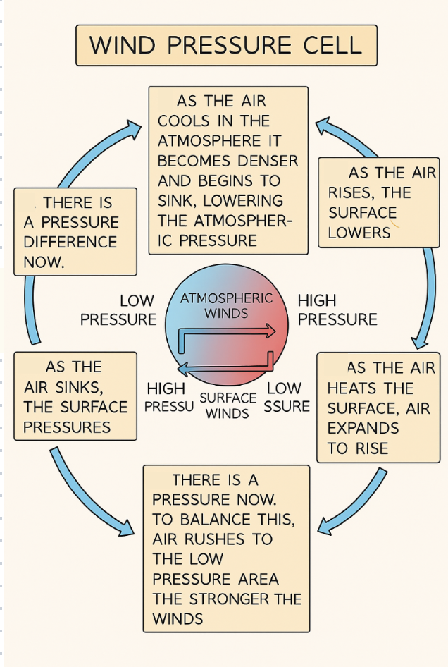
Air always moves from areas of higher pressure to lower pressure and this movement of air generates wind
Winds are large scale movements of air due to differences in air pressure
This pressure difference is because the Sun heats the Earth’s surface unevenly
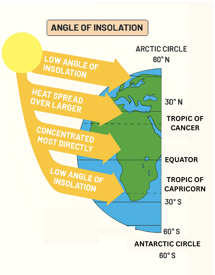
Insolation that reaches the Earth’s surface is greater at the equator than at the poles
This is due to the Earth’s curvature and the angle of the Earth’s tilt
This irregular heating of the Earth’s surface creates pressure cells
In these pressure cells, hot air rises and cooler air sinks through the process of convection
Air movement within the cell is roughly circular and moves surplus heat from equatorial regions to other parts of the Earth
In both hemispheres (the Northern hemisphere and the Southern hemisphere), heat energy transfer occurs where different atmospheric circulation cells meet
There are three types of cell
Each cell generates different weather patterns
These are the Hadley, Ferrel and Polarcells
Together, these three cells make up the tricellular model of atmospheric circulation:
Image source: savemyexams.com
The tricellular atmospheric wind model
Each hemisphere has three cells (the Hadley cell, Ferrel cell and Polar cell) that circulate air from the surface, through the atmosphere, and back to the Earth’s surface again
The Hadleycell is the largestcell and extends from the equator to between 30° and 40° north and south
Trade winds blow from the tropical regions to the equator and travel in an easterly direction
Near the equator, the trade winds meet, and the hot air rises and forms thunderstorms (tropical rainstorms)
From the top of these storms, air flows towards higher latitudes, where it becomes cooler and sinks over subtropical regions
This brings dry, cloudless air, which is warmed by the Sun as it descends: the climate is warm and dry (hot deserts are usually found here)
The Ferrelcell is the middlecell, and generally occurs from the edge of the Hadley cell to between 60° and 70° north and south of the equator
This is the most complicated cell as it moves in the opposite direction from the Hadley and Polar cells; similar to a cog in a machine
Air in this cell joins the sinking air of the Hadley cell and travels at low heights to mid-latitudes where it rises along the border with the cold air of the Polar cell
This occurs around the mid-latitudes and accounts for frequent unsettled weather
The Polarcell is the smallest and weakest of the atmospheric cells. It extends from the edge of the Ferrel cell to the poles at 90° north and south
Air in these cells is cold and sinks creating high pressure over the highest latitudes
The cold air flows out towards the lower latitudes at the surface, where it is slightly warmed and rises to return at altitude to the poles
Influence on terrestrial biomes
The tricellular model influences the distribution of precipitation and temperature across latitudes
Near the equator, rising warm air leads to high rainfall and high temperatures
This creates tropical rainforests and savannas
Tropical rainforests thrive in regions of high precipitation and warmth within the Hadleycell
Mid-latitudes experience variable weather due to interactions between warm and cold air masses, resulting in temperate climates with moderate precipitation
This creates temperate forests and grasslands
These biomes occur in areas within the Ferrel cell, with moderate precipitation and temperatures
High latitudes, influenced by descending cold air, have low temperatures and limited precipitation
This creates polar deserts and tundra
These biomes occur due to the cold, dry conditions within the Polar cell
These climatic factors, in turn, influence the structure and productivity of terrestrial biomes by affecting plant growth, water availability and average temperatures
The tricellular model therefore helps us to:
Understand the global distribution of biomes
Understand the ecological characteristics of biomes
Predict biome shifts due to climate change and global warming
Ocean currents
Solar radiation absorption
Oceans act as vast heat reservoirs
This is because they absorb the solar radiation that penetrates their surface layers
Solar energy is absorbed primarily in the top layer of the ocean
Here, it warms the water and results in thermal energy being stored
Ocean currents and heat distribution
Ocean currents play an important role in distributing the heat absorbed by the oceans around the world
Surface ocean currents, driven by winds and Earth’s rotation, transport warm water from the equator towards the poles and cold water from the poles towards the equator
These currents redistribute heat horizontally across the ocean surface
This movement of heat affects regional climates and weather patterns
Impact on climate and ecosystems
The redistribution of heat by ocean currents helps regulate global climate
This is because it helps to moderate temperature extremes
Warm ocean currents can bring milder, warmer weather conditions to coastal regions, while cold currents cool down coastal regions
Oceanic heat transport also affects marine ecosystems
They affect patterns of ocean productivity, distributions of marine species and levels of marine biodiversity